THORNTON BEACH BLUFF PRESERVE
A Proposal To Save Open Space, An Historic Community Resource & Recreational Opportunity on the California Coast
San Francisco is a top tourism destination with over 27 million visitors projected for 2020. The coast of California is world renowned for its scenic beauty, rugged coastline, beaches, wildlife and active, outdoor lifestyle. And the San Francisco Bay Area is rich in recreational traditions including sailing, kite boarding, para sailing, dog walking, hiking, surfing, biking and horseback riding.
This area in Northern California is also known for its longstanding support of environmental and wildlife conservation, protection of wetlands and open space and political commitment to providing its diverse residents and visitors, access to its many natural treasures.
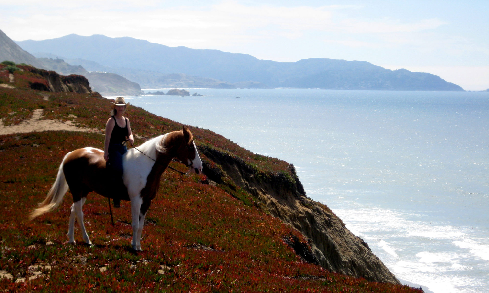
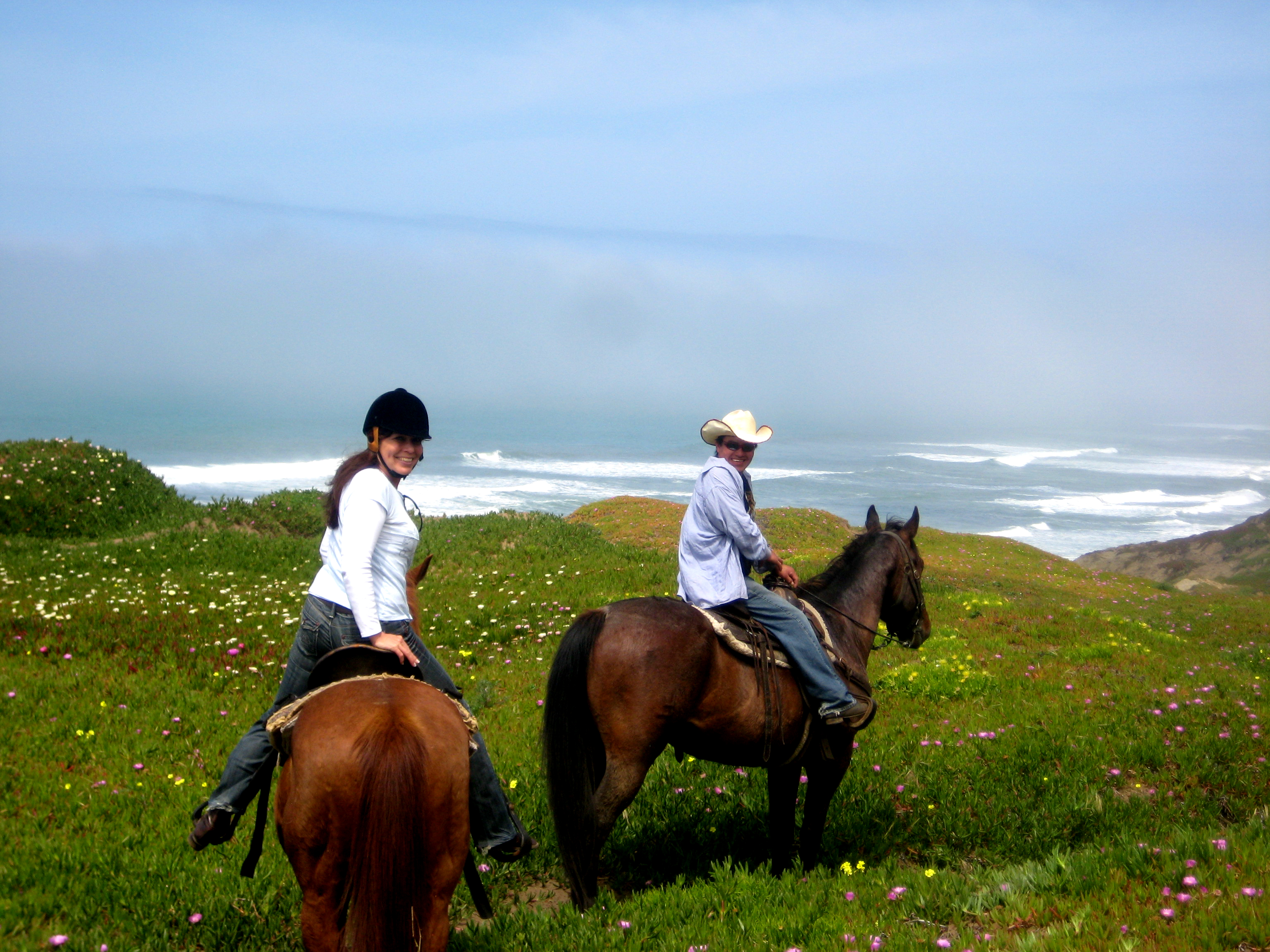
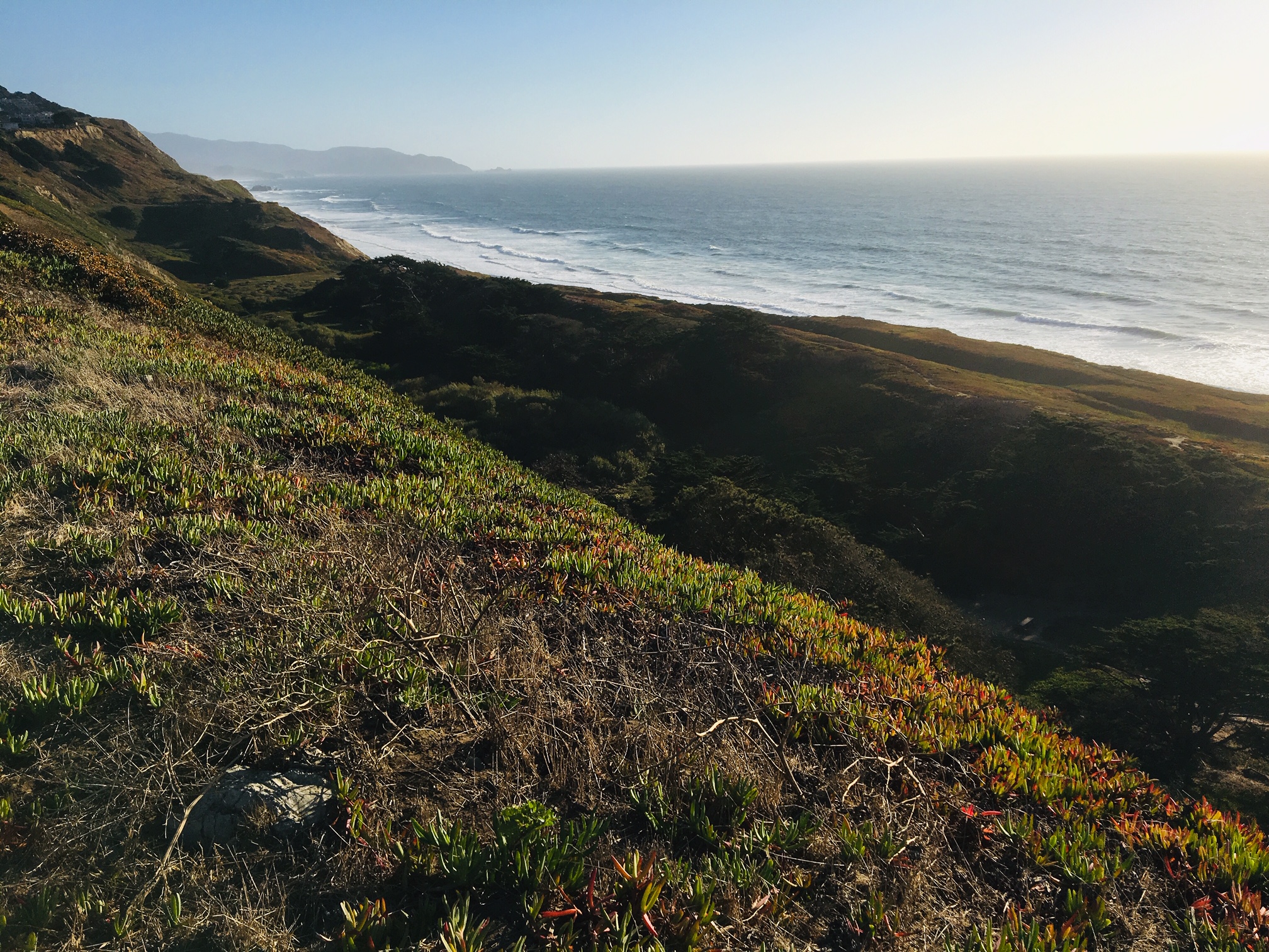
Thornton Beach Bluff in Autumn
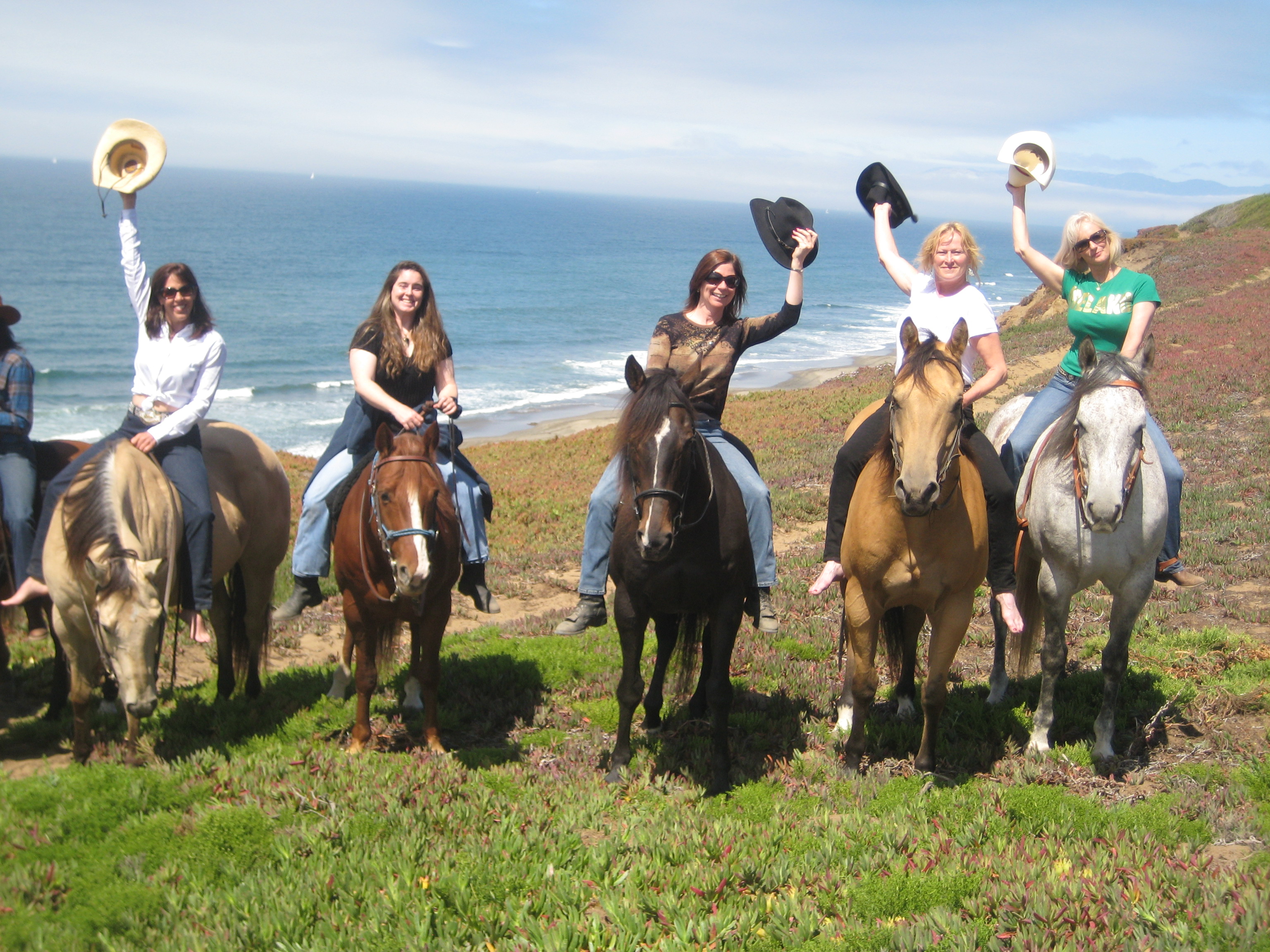
Perched over Thornton State Beach and lying just south of Fort Funston, a federally-protected area within the Golden Gate National Recreation Area, is Thornton Beach Bluff, a popular destination for dog walkers, hikers, equestrians and water-sports enthusiasts.
Fort Funston, Thornton Beach Bluff and Mar Vista Stables have together become an important community anchor for recreation for thousands of people living in and visiting the Bay Area.
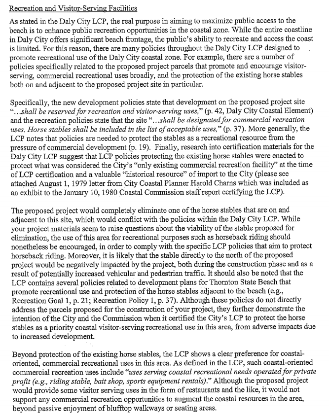
Thornton Beach Bluff is home to Mar Vista Stables. Horses have been part of the Bay Area’s history for over 130 years and Mar Vista Stables is the only remaining year-round stables offering riding opportunities to the general public, including both many Bay Area visitors as well as residents. The stables are historic and were temporarily occupied by the Coast Guard in WWII to watch for enemy Japanese ships. Mar Vista Stables offers horseback riding trail rides to a diverse set of aspiring riders among the general public, novices to experts, from 8 year olds to 78 year olds, horseback riding camps, riding and horsemanship lessons and private horse boarding and leasing. Every year, approximately 4,600 Bay Area residents and visitors ride out on the trail at Thornton Beach Bluff and down the bluffs to Ocean Beach.
The survival of this recreational paradise is at stake.
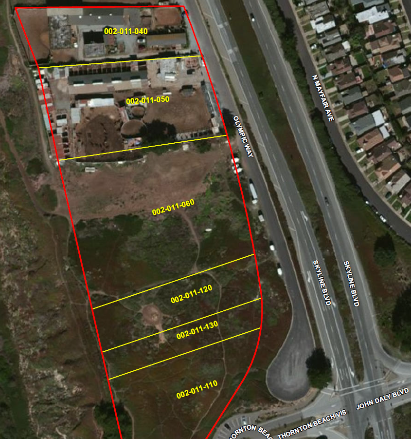
The owners of the properties to the south of the Olympic Club at 2152 Skyline Boulevard, Daly City, CA (parcels 002-011-040, 002-011-50, 002-011-060, 002-011-120, 002-011-130, ) are interested in selling their land to developers. This follows several 2019-2021 attempts by developers to acquire the land and build commercial buildings (hotels, event centers) on this property.
A summary of the 2021 Sand Hill Properties project proposal is here.
See: Daly City Planning’s Pre-Application Response Letter dated September 12, 2019
California Coastal Commission’s letter dated October 9th 2019.
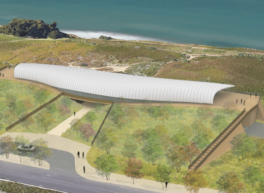
(Schematic of Sand Hill Properties Development’s Proposal)
We believe that this land is a critical community resource which should be saved for recreation and open space. We want to use community advocacy to forever protect this land for trail riders, dog walking, hikers and other open space recreation.
Our rationale for this vision is the following:
- Commercial development in an area with fragile, sand coastal cliffs near the San Andreas Fault is a bad idea especially when development requires that infrastructure (underground utility lines) must be brought under existing roadways (Skyline Boulevard) to provide electricity, sewer/groundwater etc.
Reference the 2 geologic reports (Cotton Shires, February 2019) and (ENGEO, April 2019) prepared for Sand Hill Properties which clearly articulate the risk of landslides and seismic activity present at the site.
The USGS put the chance at a 6.7+ magnitude (major) earth quake in the San Francisco Bay Area at 72% over the next 25 years.
- Coastal erosion is increasing due to climate change. A 5+ foot rise in sea level in California is projected by 2100 which will lead to further bluff and seawall erosion on Thornton State Beach.
Seaside cliffs have crumbled in Daly City just south of Mar Vista on Northridge and Avalon Drives with slides in 2003 and 2007 and 17 homes were declared unsafe on Westline Drive as the result of another slide in 2000. A report, released in December 2017 by UC San Diego’s Scripps Institution of Oceanography, employed a high-tech surveying method called lidar to evaluate erosion along 680 miles of the California coast. The coast of Daly City was identified as one of the state’s riskiest sites for collapsing cliffs.
In Pacifica, where cliff erosion has forced the demolition of 3 apartment buildings and 3 homes, the city is using eminent domain to buy land where two of the apartments were located so that it can create a buffer to prevent future cliff collapses because a sewer line is located beneath the street.
In addition, the 2016 FEMA Sea Level Rise Pilot Study noted that “a 1.4 m sea‐level rise will accelerate erosion, resulting in a loss of 41 square miles of California’s coast by 2100″.
- Daly City’s General Plan 2030 (pp. 173 to 184) identifies a strong need for open space in the city: “Open space is one of the most precious and limited natural resources in Daly City. As identified by the General Plan Land Use Map, approximately 400 acres within Daly City will continue to remain designated as Open Space Preservation on the General Plan Land Use Map. Areas within this acreage are a large conglomeration of vacant parcels along the coastline that, because of environmental constraints such as steep slopes and unstable soils, have limited development potential.“
“In addition to their designation as Open Space Preservation in the General Plan, coastal bluff areas are protected through the Resource Protection (-RP) Combining District of the Zoning Ordinance. This combining district prohibits construction within 50 feet of the bluff top, on a slope greater than thirty percent, or where the vertical relief is ten feet or greater. The district also prohibits grading or filling operations except for those required as drainage and erosion control measures, and requires permanent vista corridors of at least five feet or 15 percent of the lot, whichever is greater, for any development which occurs within the district.” “At the coastline, Thornton Beach State Park, which has been made largely inaccessible due to landslides, now provides a panoramic overlook and parking lot adjacent to Highway 1, at the end of the John Daly Boulevard.”
- The Local Coastal Plan for Daly City is clear about protections for recreation, views from the street, and other restrictions on development which this project violates:
- “The private property north of the Thornton State Beach access road shall be designated for commercial recreation uses.”
-
New development of properties referred to policies 3, 4, and 5 above, if permissible, shall include the following:
a) Improved vehicular access and extension of public services to the site shall be allowed only as necessary to serve permitted development;
b) Location of development within the site shall be in the least hazardous and least visually obtrusive configuration feasible.
c) Land coverage shall be compatible with the open space character and shall be less than 10% of the site area.
d) Structural mass shall be compatible with the open space character and shall be less than 20 feet in height or one-story above grade, whichever is less. (Goals 1 & 3 and Sections 30250(a) & 30253)
- Loss of coastal views in Daly City violates the Daly City Coastal Element LCP development policies:
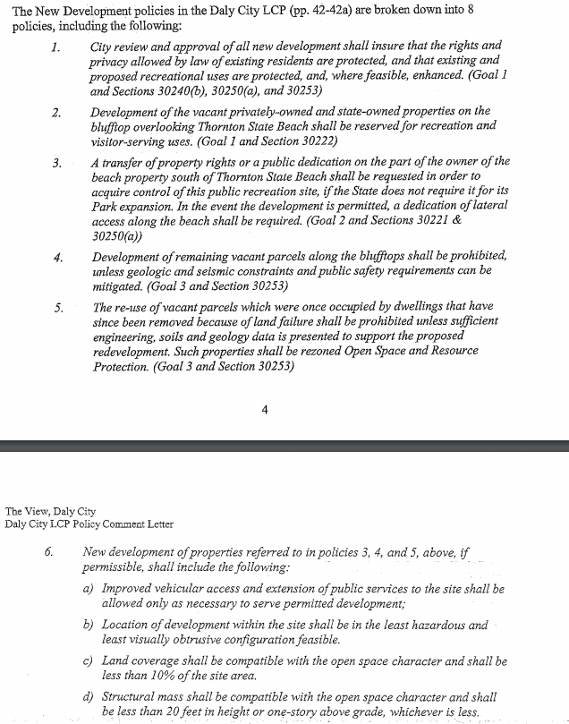
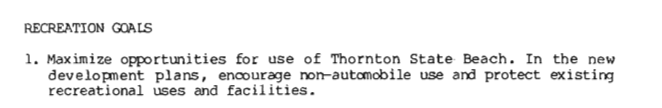
- Development is also not in line with the LCP’s recreation goals as stated in the plan:

- The land is currently zoned as Light Commercial (C-1) Zoning District in a Resource Protection (RP) Combining District within the Coastal Zone. The project is inconsistent with these uses as stated in the The Daly City Zoning Ordinance with permitted uses in the C-1 zone including “retail, offices and services of the type and scale normally found in a neighborhood shopping center. Uses allowable with a Use Permit include restaurants, theaters, gas stations, animal kennels and nurseries”. “Allowable development in an RP zone adjacent to open space designations have development regulations that ensure a compatibility with the area such that development does not contribute to adversely impact such areas that have sensitive habitat resources or geologic hazard constraints”.
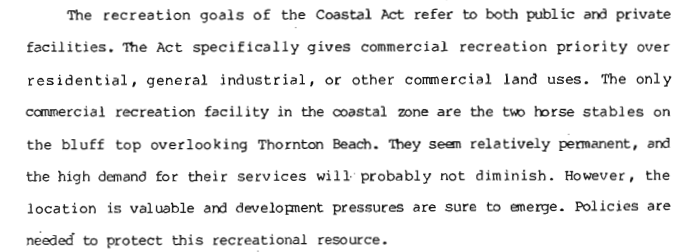
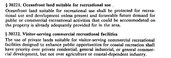
- Development is contrary to the California Coastal Act’s priority on recreational use:
- We believe this development should not be supported by the California Coastal Commission especially given the 2016 Amendments to California’s Coastal Act:
- Article 2 mandates that development shall not interfere with the public’s right to access the (sea including dry sand beach) beach.
- Article 3 covers recreation, placing a priority on coastal dependent public and private recreation over residential development.
- Article 5 includes protections for environmentally sensitive habitat, agriculture and archeological resources.
- Article 6 deals with development and issues such as protection of coastal views, limitations on coastal armoring and landform alteration, and geologic hazards.
- Article 7 covers industrial development.
- Skyline Boulevard, (Route 35) is eligible to be a State-designated Scenic Highway under the State Scenic Highways program and potential loss of coastal views is a concern of the Daly City Planning Department’s DEIR on Aesthetics:
- This land lies on the original Ridge Trail.
The Bay Area Ridge Trail Council originally created 200 miles of existing trail on public lands by 1995. And today, 375 miles of the Bay Area Ridge Trail are ready to explore by outdoor enthusiasts with 80% open to bikes and horses. Bit-by-bit continuous sections are being knit together to provide true thru-hike (or bike, or ride!) opportunities. Community support of the Ridge Trail includes numerous local and national conservation associations and organizations:
- This land lies within the habitat for at least 2 endangered species (the SF Garter Snake and CA Red Legged Frog) which could violate the sensitive habits section of the San Mateo Planning and Building Department’s policies on Sensitive Habits Sections 7.1 to 7.5. This could be an issue from the point of view of the Sierra Club and other wildlife protection advocacy groups.
A pair of Great Horned Owl nests in the Valley just below the stables. Barn Swallows nest in the rafters in the barn and are protected by state and federal law during their nesting season under the Migratory Bird Treaty Act of 1918. The enforcement agency, the California Department of Fish and Game, considers Feb. 15 to Sept. 1 to be swallows nesting season. Completed nests during this breeding season cannot be touched without a permit from the U.S. Fish and Wildlife Service.

- The only public access to Thornton Beach for hikers, dog walkers, surfers, parasailers, fire department, police department (other than the Fort Funston stairs) is the path on one of these parcels. The CA Coastal Commission states:

This is also a critical access issue according to the Daly City Local Coastal Program
- In our opinion, the project is subject to claims by the public for a prescriptive rights easement.
- Broad use of this area by the public was cited in the 1995 Olympic Club Coastal Commission Permit for its golf course extension on the land immediately to the north of the Mar Vista and Palomar Stables sites:
The Coastal Commission’s 1996 report cites an important provision surrounding a right of public access acquired through use.
This has precedence (pages 21-22) in it’s report on the Olympic Club’s project:
(d) Provision of Public Access Equivalent In Time Place and Manner.
As noted previously, where there is substantial evidence of the existence of a
public access right acquired through use, and a proposed development would
interfere with that right, the Commission may deny a permit application under
Public Resources Code section 30211. As an alternative to denial, the
Commission may condition its approval on the development being modified or
relocated in order to preclude the interference or adverse effect. This is
because the Commission has no power to extinguish existing public rights, even
though it may authorize development which affects the exercise of those rights.
Section 30214 of the Coastal Act directs the Commission to implement the public access policies of the Act in a manner which balance various public and private needs. This section applies to all the public access policies, including those dealing with rights acquired through use. Therefore, the Commission must evaluate the extent to
which the proposed public access is equivalent in time, place, and manner to
the public use that has been made of the site in the past.
The Coastal Commission’s 1996 report (page 23) cites a public access easement granted in perpetuity by the Olympic Club for use by the community for recreational uses:
As proposed by the applicant, the grant deed of easement would
provide for access in perpetuity over a 31-acre area extending along the
entire length of the Olympic Club property, from Fort Funston to Thornton
State Beach. The property includes not only ocean-front land in San Francisco
within the Commission’s jurisdiction, but also ocean-front land in San Mateo
County. The easement grants the National Park Service the rights to establish
and maintain trails for pedestrian and equestrian uses for the general public, and the right and obligation to monitor, police and patrol over and across the
easement area. The deed of easement provides that use of the easement shall
be deemed for “recreational purposes” as defined in Section 846 of the
California Civil Code.
The definition of “recreational purpose” provided in Civil Code Section 846 is as
follow:
“A ‘recreational purpose,’ as used in this section, includes such
activities as fishing, hunting, camping, water sports, hiking, spelunking, sport parachuting, riding, including animal riding, snowmobiling, and all other types of vehicular riding, rock collecting, sightseeing, picnicking, nature study, nature contacting, recreational gardening, gleaning, hang gliding, winter sports, and viewing or enjoying historical archaeological, scenic, natural, or scientific
sites.”
- Finally, please reference the Coastal Commission’s letter to Torgon Group (Canadian developers) dated 8-25-2014 stating the Commission’s objections to the development of this property in general and particularly given the closure of Thornton State Beach by California in 1989: